
The INCA Models Used in Aquascope
Project type: Advanced catchment modelling for high-integrity Water, Carbon, and Biodiversity MRV
Partners: WRA (INCA modelling)
Overview
Aquascope integrates the Integrated Catchment (INCA) family of models to deliver world-class monitoring, reporting, and verification (MRV) for nature-based projects. With more than 25 years of development and real-world application across Europe, Asia, Africa, Oceania, and the Americas, the INCA suite provides the scientific backbone for our water quality, carbon flux, hydrological and ecological assessments.
1. Introduction
Versions of the INCA model have been developed for a wide range of water quality parameters and hydrological processes. These models simulate how pollutants, nutrients, sediments, pathogens, carbon, metals, and other materials move through landscapes and rivers, allowing Aquascope to understand and forecast environmental change at a daily temporal resolution. All INCA models represent both terrestrial (land-based) and in-stream (river-based) processes, including inputs from agriculture, wastewater, land management, and atmospheric deposition; transformations such as nitrification, mineralisation, sorption, algal uptake, and carbon cycling; transport of dissolved and particulate materials; and loss pathways including gaseous emissions or burial in sediments. This process-based structure makes INCA uniquely suited for modelling complex ecosystems such as wetlands, peatlands, forests, grasslands, and mixed-use agricultural catchments.
2. The INCA Family of Models
2.1 INCA-N: Nitrogen
INCA-N simulates the fate and transport of nitrate (NO₃⁻) and ammonium (NH₄⁺), capturing soil nitrogen transformations, groundwater transport, river mixing and assimilation, and seasonal agricultural inputs. This model is essential for understanding eutrophication, nitrogen saturation, agricultural leaching, and climate impacts on water quality.
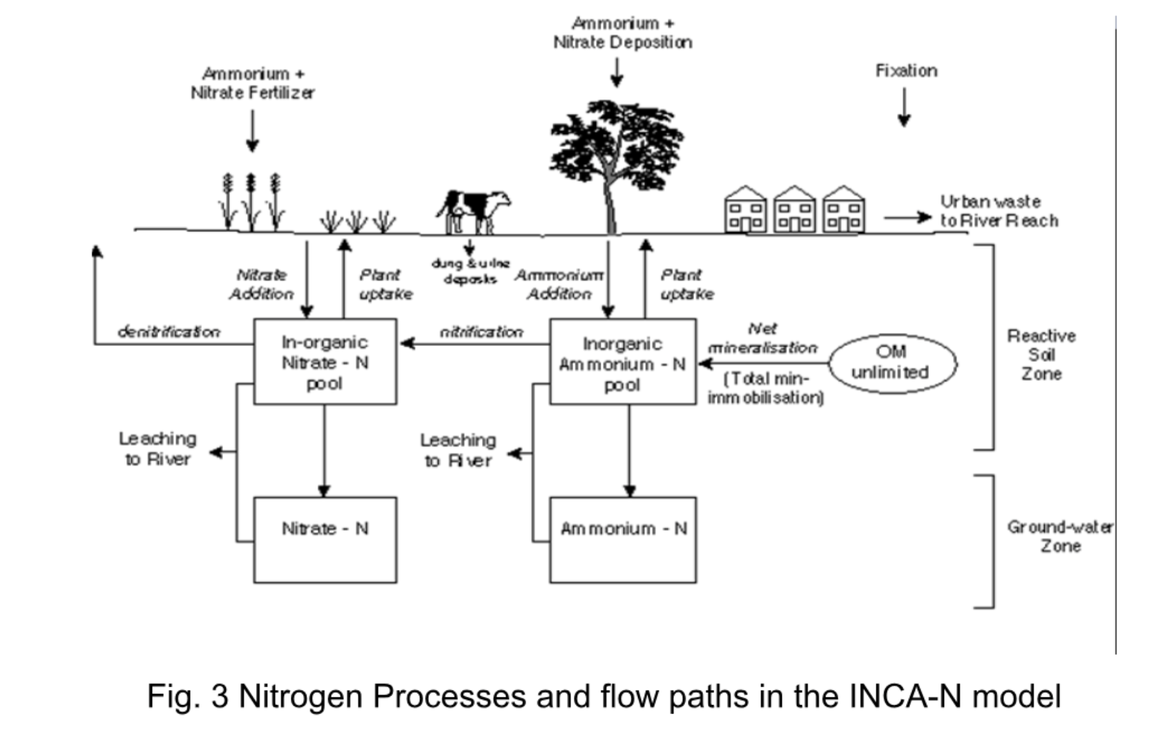
Fig. 3 Nitrogen processes and flow paths (INCA-N)
2.2 INCA-P & INCA-PEco: Phosphorus and Ecology
INCA-P simulates the transport and cycling of dissolved phosphorus (TDP, SRP), particulate phosphorus (PP), organic phosphorus, and soil and sediment interactions (adsorption–desorption, Langmuir isotherm processes). The ecological extension INCA-PEco adds phytoplankton dynamics, macrophytes and epiphytes, DO/BOD behaviour, and streambed and sediment interactions.
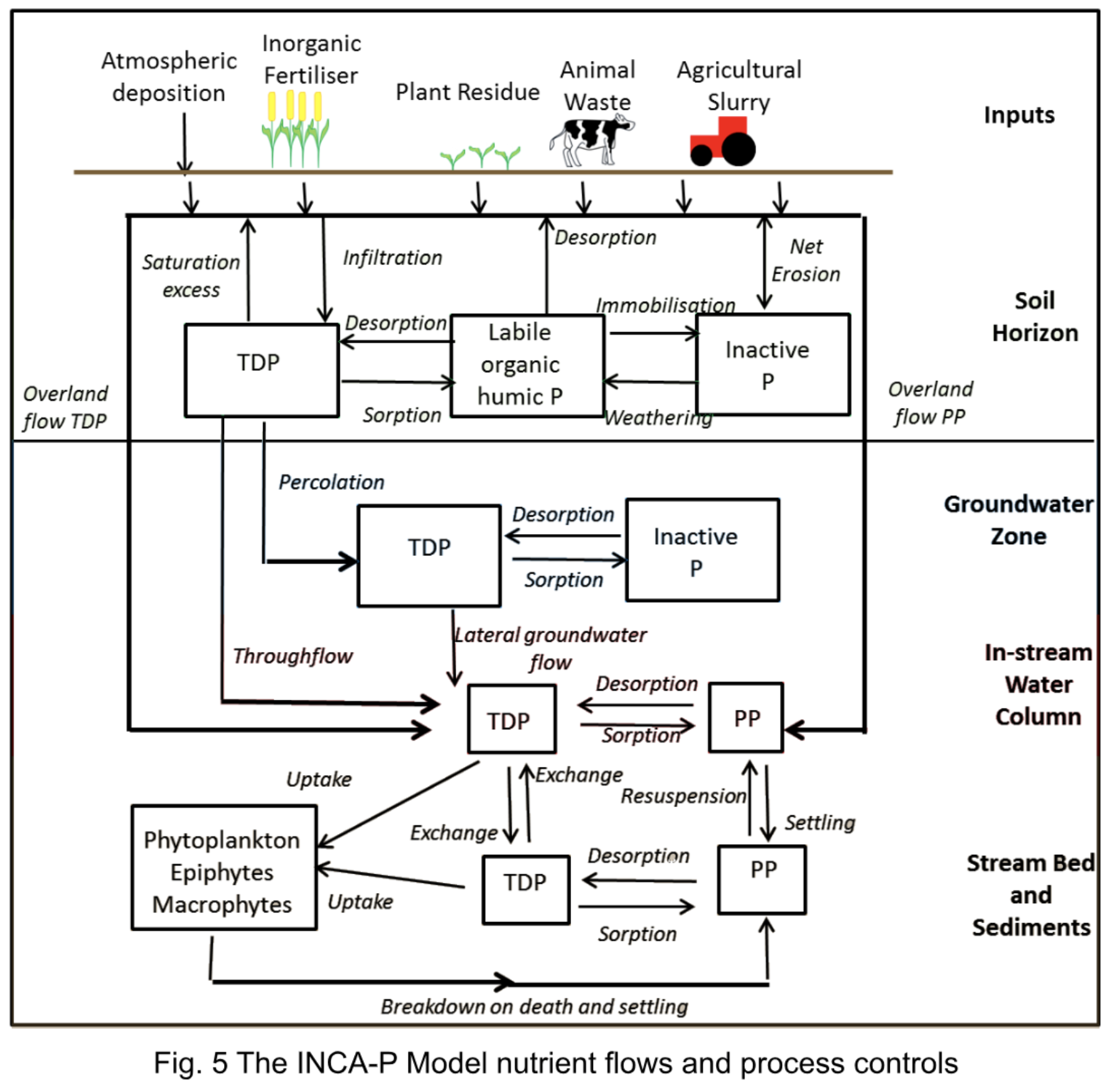
Fig. 5 INCA-P nutrient flows and process controls
2.3 INCA-C: Carbon
INCA-C focuses on dissolved organic carbon (DOC) mobilisation and cycling, particularly relevant for peatlands, forested catchments, acidification recovery, and climate-sensitive DOC export.
2.4 INCA-Sed: Sediment
A physically based sediment transport model that simulates soil erosion, sediment mobilisation, deposition, and resuspension. Now embedded within the latest INCA-P versions.
2.5 INCA-Contaminants
Simulates a broad suite of anthropogenic pollutants including persistent organic pollutants (POPs), microplastics, metaldehyde, and PFAS.
2.6 INCA-Path: Pathogens
Models E. coli and other pathogens, assessing agricultural and wastewater influences.
2.7 INCA-Metals & INCA-Hg
Models heavy metal transport, mercury and methylmercury processes.
2.8 PERSiST Hydrological Model
A flexible eco-hydrological rainfall–runoff model used to generate soil moisture deficit, hydrologically effective rainfall, groundwater delays, and flow pathways. PERSiST is often used as the hydrological engine underlying INCA modules.
3. How INCA Works: Model Structure
INCA is a daily, dynamic, mass-balance, semi-distributed catchment model. It is structured into Level 1: River catchment; Level 2: Sub-catchments (1 to 6 land-use types each); and Level 3: Land-phase cell model (soil and groundwater processes).
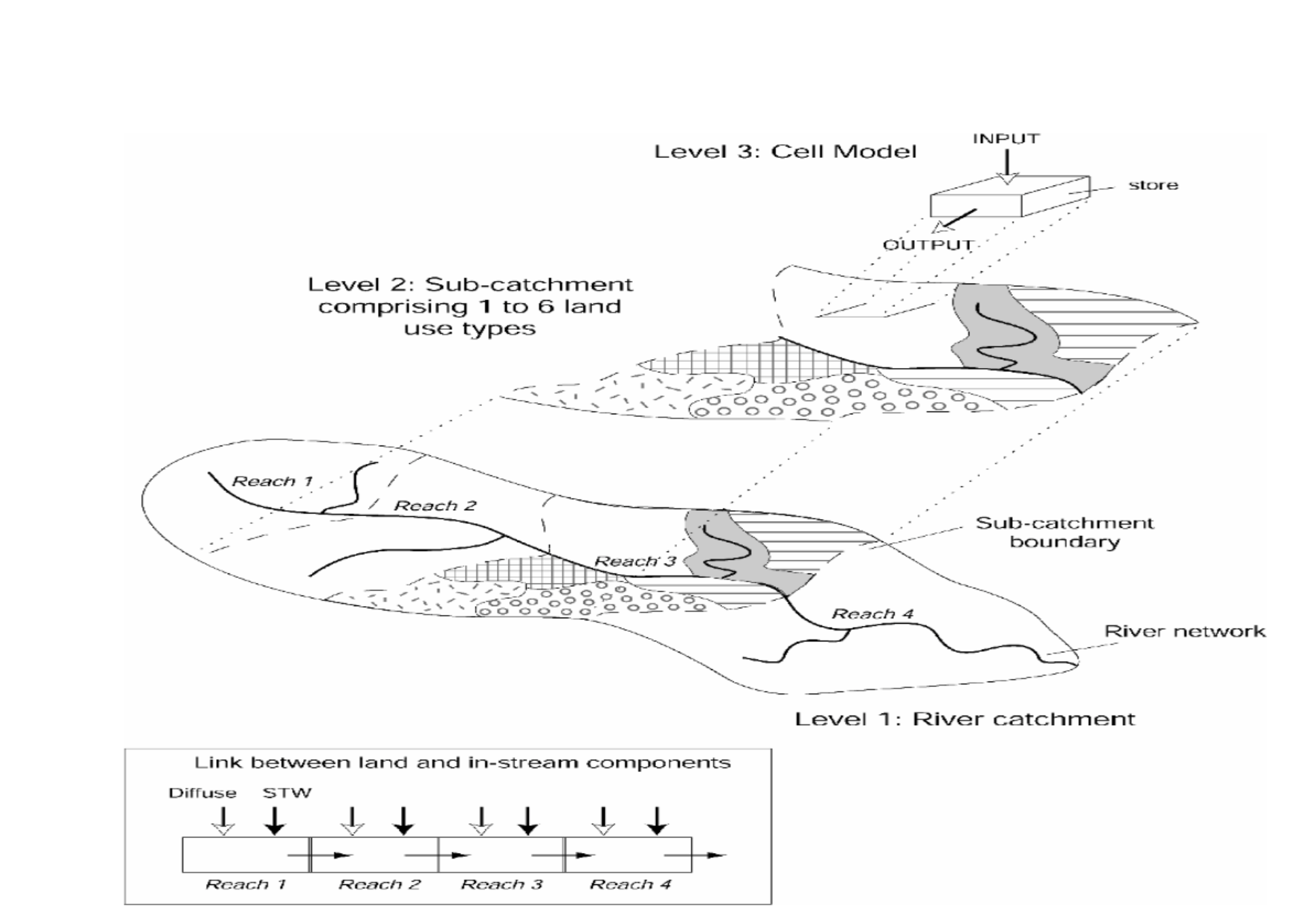
Fig. 2 Landscape and in-stream integration (INCA model structure)
3.1 GIS-Based Catchment Representation
Sub-catchments defined by digital elevation models, up to six land-use classes per sub-catchment, and combined land and river processes scaled through multi-reach routing.
3.2 Land-Phase Hydrology
INCA simulates soil water movement, groundwater contributions, direct runoff, and subsurface and slow-flow hydrological processes. Driven by Soil Moisture Deficit, Effective Rainfall, Temperature, and Precipitation.
3.3 Land-Phase Biogeochemistry
Processes include Nitrogen: mineralisation, nitrification, denitrification, plant uptake; Phosphorus: adsorption, desorption, erosion, sediment interactions; Carbon: DOC production and leaching; and Sediments: mobilisation and transport.
3.4 In-Stream River Processes
INCA uses a multi-reach river network to simulate dilution and mixing, algal uptake and respiration, DO/BOD dynamics, sorption–desorption exchanges, and settling, burial, resuspension.
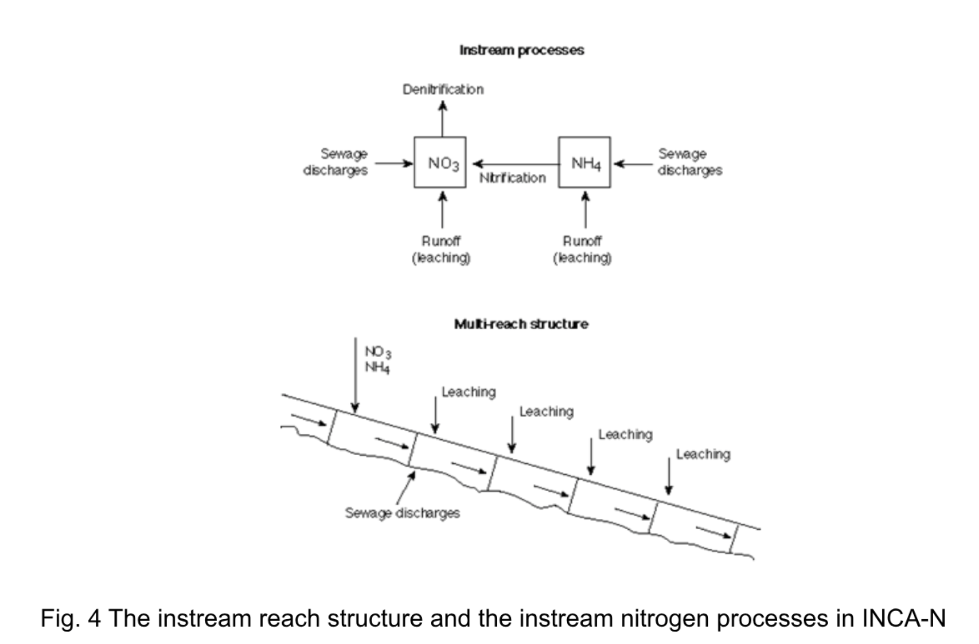
Fig. 4 Instream reach structure and nitrogen processes (INCA-N)
4. Data Requirements
INCA can operate in data-poor or data-rich environments. The model requires spatial data (land use classifications, soil and geology, sub-catchment boundaries), meteorological data (precipitation, temperature, soil moisture deficit, hydrologically effective rainfall), and management data (fertiliser amounts and timing, livestock densities, wastewater discharges, growing season parameters).
5. Model Outputs
INCA generates daily flows and concentrations (N, P, DOC, sediments, pathogens, metals), annual nutrient fluxes, land-use-specific loads, reach-by-reach river profiles, cumulative probability distributions, and full mass-balance closure for audit verification. These outputs feed directly into Aquascope's analytics, scenario comparisons, and certification-ready MRV.
6. Global Applications of INCA
INCA has been applied to catchments worldwide, including Europe: Thames, Wye, Cleddau, Tweed, Garonne; Africa: Volta, Awash; Asia: Ganges, Brahmaputra, Mekong, Nepalese headwaters; Oceania: Murrumbidgee, Waikato; North America: Lake Simcoe; and Urban systems: Dhaka River Basin. Applications include eutrophication mitigation, climate change planning, wetland and peatland recovery, pollution control, and heavy metal and contaminant modelling.
7. How Aquascope Enhances INCA
Remote Sensing
Sentinel-1 and Sentinel-2 water dynamics, vegetation indices, soil moisture, and algal bloom proxies.
Field Sensors
Biosensors for toxicity, methane sensors, soil carbon probes, and continuous water quality loggers.
AI & Predictive Analytics
Automated calibration, scenario modelling, biodiversity inference from water quality, and long-term degradation/restoration forecasting.
References
- Crossman, J., Bussi, G., Whitehead, P.G., Butterfield, D., Lannergård, E. and Futter, M.N. (2021). A New, Catchment-Scale Integrated Water Quality Model of Phosphorus, Dissolved Oxygen, Biochemical Oxygen Demand and Phytoplankton: INCA-Phosphorus Ecology (PEco). Water, 13, 723.
- Wade, A.J., Butterfield, D., Griffiths, T. and Whitehead, P.G. (2007). Eutrophication control in river-systems: an application of INCA-P to the River Lugg. HESS, 11(1), 584–600.
- Wade, A.J., Butterfield, D. and Whitehead, P.G. (2006). Towards an improved understanding of the nitrate dynamics in lowland, permeable river-systems: Applications of INCA-N. Journal of Hydrology, 330(1–2), 185–203.
- Neal, C. (2002). Assessing nitrogen dynamics in catchments across Europe within an INCA modelling framework. Hydrology and Earth System Sciences, 6(3), 297–298.
- Wade, A.J., Durand, P., Beaujouan, V., Wessel, W.W., Raat, K.J., Whitehead, P.G., Butterfield, D., Rankinen, K. and Lepistö, A. (2002). Towards a generic nitrogen model of European ecosystems: INCA, new model structure and equations. Hydrology and Earth System Sciences, 6, 559–582.
- Whitehead, P.G., Wilby, R.L., Butterfield, D. and Wade, A.J. (2006). Impacts of Climate Change on Nitrogen in Lowland Chalk Streams: Adaptation Strategies to Minimise Impacts. Science of the Total Environment, 365, 260–273.
- Whitehead, P.G., Wilson, E.J. and Butterfield, D. (1998a). A semi-distributed nitrogen model for multiple source assessments in catchments (INCA): Part I – model structure and process equations. Science of the Total Environment, 210–211, 547–558.
- Whitehead, P.G., Wilson, E.J., Butterfield, D. and Seed, K. (1998b). A semi-distributed nitrogen model for multiple source assessments in catchments (INCA): Part II – application to large river basins in South Wales and eastern England. Science of the Total Environment, 210–211, 559–584.
- Whitehead, P.G., Heathwaite, A.L., Flynn, N.J., Quinn, P.F., Hewett, C. and Wade, A. (2007). Evaluating the Risk of Non-point Source Pollution from Sewage Sludge: Integrated Modelling of Nutrient Losses at Field and Catchment Scales. Hydrology and Earth System Science Journal, 11(1), 601–613.
- Wilby, R.L., Whitehead, P.G., Wade, A.J., Butterfield, D., Davis, R.J. and Watts, G. (2006). Integrated Modelling of climate change impacts on water resources and quality in a lowland catchment: River Kennet, UK. Journal of Hydrology, 330(1–2), 204–220.
- Jarvie, H.P., Wade, A.J., Butterfield, D., Whitehead, P.G., Tindeall, C.I., Virtue, W.A., Dryburgh, W. and McGraw, A. (2002). Modelling nitrogen dynamics and distributions in the River Tweed, Scotland: an application of the INCA model. Hydrology and Earth System Sciences, 6, 297–615.
- Flynn, N.J., Paddison, T. and Whitehead, P.G. (2002). INCA modelling of the Lee system: strategies for the reduction of nitrogen loads. Hydrology and Earth System Sciences, 6, 467–485.
- Neal, C. (Ed.). (2002). Assessing nitrogen dynamics in catchments across Europe within an INCA modelling framework. Hydrology and Earth System Sciences, 6, 297–616.
- Wade, A.J., Whitehead, P.G. and Butterfield, D. (2002b). The Integrated Catchments model of Phosphorus dynamics (INCA-P). HESS, 6(3), 583–506.
- Whitehead, P.G., Johnes, P.J. and Butterfield, D. (2002). Steady state and dynamic modelling of nitrogen in the River Kennet: impacts of land use change since the 1930s. Science of the Total Environment, 282–283, 417–435.